Hancock County (Georgia) Cemeteries
Cemetery details
Mt. Moriah Church Cemetery

Location:
From the Hancock County Courthouse, take Hwy 22 southwest for 7.2 miles to Devereux. Turn right (at the backwards fork) onto Main Street. Go 0.2 mile to the dead end and turn left onto Jones Chapel Road. Go 4.9 miles. Turn right on Carr Station Road and go for 8.6 miles. Turn right on Lake Sinclair Drive and go for 3.9 miles. Turn left on Island Creek Drive and go for 2.9 miles. Turn right on Ridge Road and go for exactly 0.7 mile. Walk 150 feet into the woods on the right to the cemetery.
From the Hancock County Courthouse, take Hwy 22 southwest for 7.2 miles to Devereux. Turn right (at the backwards fork) onto Main Street. Go 0.2 mile to the dead end and turn left onto Jones Chapel Road. Go 4.9 miles. Turn right on Carr Station Road and go for 8.6 miles. Turn right on Lake Sinclair Drive and go for 3.9 miles. Turn left on Island Creek Drive and go for 2.9 miles. Turn right on Ridge Road and go for exactly 0.7 mile. Walk 150 feet into the woods on the right to the cemetery.
GPS coordinates: 33 10' 56.1" N 83 13' 36.5" W
or in degrees only form: 33.18225° N X 83.22681° W
See location on a Google map in a new window (NOTE:The map opens in a new window. The cemetery will be at the location indicated by a red marker.)
GMD: 105
Cemetery Status: Inactive
Predominant race: Black
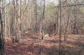
About 80-100 graves in rows are spread over a large area. Many are only depressions or only have rocks or stones for headstones. Several headstones have fallen onto the ground.
It is believed this cemetery is associated with the Mt. Moriah Baptist church, which was formed in 1875.
Indexer or Contributor: Mona L. and F. Dean Williams
Henry Roberson
1885 - Nov 14, 1910
Grave 2
Alic Hubberd
1907 - Sep 10, 1914
Grave 4
Unmarked Grave
Marked by a rock.
Grave 7
Annie Lee Cumming
Nov 5, 1889 - Jun 3, 1911
"The Lord gave and the Lord hath taken away. Blessed be the name of the Lord."
Click for more info.
Click for more info.
Grave 8
Ethel Hubberd
Slab has fallen sideways into the ground. Handwritten. No dates.
Grave 9
Unmarked Graves
Many depressions scattered all through the area in rows.
Grave 11